You are currently browsing the tag archive for the ‘Michigan’ tag.
This post begins an ongoing blog series highlighting various complete street elements, their benefits, and use in Michigan communities. Check back often to catch future posts, and keep a lookout for these elements in your community!
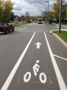
What are Sharrows? Shared-lane markings, often called sharrows, indicate proper lateral positioning for bicyclists riding on roadways. The sharrow design consists of a bicycle symbol with a double set of chevrons, pointing in the direction a bicyclist should ride.
![photo[1]](../../michigancompletestreets.files_subdomain/2013/10/photo1.jpg)
A sharrow on Michigan Ave in Lansing helps a bicyclist ride in good position
- Assisting bicyclists with lateral positioning in a shared lane with on-street parallel parking in order to reduce the chance f a bicyclist’s impacting the open door of a parked vehicle,
- Assisting bicyclists with lateral positioning in lanes that are too narrow for a motor vehicle and a bicycle to travel side by side within the same traffic lane,
- Alerting road users of the lateral location bicyclists are likely to occupy within the traveled way,
- Encouraging safe passing of bicyclists by motorists, and
- Reducing the incidence of wrong-way bicycling.
When to Use Sharrows: Sharrows can be found on roads under 35 mph. Proper placement of sharrows (per MMUTCD) is immediately after intersections, and no more than 250 feet apart thereafter. Some factors that influence lateral placement of sharrows on roads are road width, changes in road width, and the presence or absence of on-street parking. Sharrows can also be used to tell cyclists where to ride when bike lanes stop and start again.
Sharrows placed where bike lanes end can help bicyclists with proper positioning when coming back into the flow of traffic
Safety Benefits: Data suggest that sharrows are effective traffic safety measures for cyclists. A 2010 Federal Highway Administration review found that a high percentage of cyclists rode over sharrows, increasing their visibility and protecting them from collisions with parked-car doors. Cars also afforded cyclists more riding room between them and curbs or parked cars. A 2011 Los Angeles DOT study found that sharrows significantly increase vehicle passing distance, and for cars that do not pass, drivers typically exhibited less aggressive behavior and tailgated less. A 2004 San Francisco study found that cars gave cyclists 3-4 more inches of riding room when sharrows were present. Sharrows were also associated with a 25-35% decrease in sidewalk riders, possibly indicating a greater comfort level with riding on a sharrow-marked road.
Sharrows are often accompanied by signage alerting drivers to be aware of bicyclists
What Drivers Should Know: While it may be tempting to think that the main purpose of sharrows is to denote a shared-space between bicyclists and motorists, sharrows are more about where cyclists should ride on the road—bicycles and vehicles must always share the road in Michigan, regardless of markings. Sharrows do tell motorists where bicyclists are likely to ride, and where bicyclists may be reentering the roadway where bike lanes end.
Cost Considerations: Using sharrows is a cost effective way for municipalities to increase roadway safety. The treatment does not require road widening or repaving, and applying the marking is relatively inexpensive. Material costs for shared-lane markings are around $150 per pavement marking, and around $200-250 depending on the application method. Per the MMUTCD, sharrows are used about every 250 feet and after each intersection. On a two way street, this means around 40 markings per mile at a cost of $6,000. Based on block length and intersection location, though, it is unlikely that a community would need this many sharrows, so costs would likely be lower.
Sharrows are low-hanging fruit that can make a significant and immediate impact. Michigan communities have taken notice, and sharrows are becoming more common as complete streets policies have gained steam. Flint holds the distinction being the first Michigan community to have sharrows, and Michigan State University, Grand Rapids, Royal Oak, Elk Rapids and many others have followed suit.
Have Sharrow in your community? Let us know.
Check out these resources for more information.
What Every Driver Should Know About Bike Lanes
Next Topic: Pedestrian Hybrid Beacons Explained
By Brad Neumann, Michigan State University Extension.
Three years after Michigan’s complete streets legislation became law, design guidance is improving and research into the benefits of complete streets is continuing to emerge, yet funding for projects is lean and implementation seems limited.
The concept of complete streets has officially been on the radar of local governments and transportation agencies in Michigan since 2010, when communities were given new planning and coordination responsibilities related to multimodal transportation planning. Yet some practitioners say there has been little progress made beyond the scattered adoption of resolutions and ordinances. Has the movement towards roadways planned, designed, and constructed to provide appropriate access to all legal users…whether by car, truck, transit, assistive device, foot or bicycle, stalled?
Some proponents of complete streets point to transportation engineers as an obstacle, saying the rule book that engineers have to follow is not accommodating to non-motorized users. However, in September 2013 the Federal Highway Administration (FHWA) publically supported two sets of guidelines that are oriented towards the creation of more walkable and bikeable urban environments. The FHWA encouraged transportation agencies nationwide to turn to the National Association of City Transportation Officials (NACTO) Urban Bikeway Design Guide and the Institute of Transportation Engineers (ITE) Designing Urban Walkable Thoroughfares. The two new guidelines go beyond the American Association of State Highway and Transportation Officials (AASHTO) ‘green book’, which is the principal national transportation design resource. So, it seems the engineering guidance is out there and planners can no longer blame the engineers’ rule books.
Other critics say there has been too much emphasis on promoting the environmental, health, recreation and lifestyle benefits of increased walking and cycling. They say the message needs to refocus on the safety and economic benefits of complete streets. Indeed, there is substantial research connecting health to community design and evidence shows a majority of people currently fall into the recreational cycling category of “Interested but Concerned” (that is, interested in cycling, but concerned about safety). Regarding safety, for decades research has shown that a cyclist riding on the sidewalk is at least twice as likely to get in an accident than a cyclist riding in the street (Wachtel and Lewiston, 1994), and streets with bike lanes have significantly lower crash rates than either major or minor streets without any bicycle facilities. However, even cities with relatively good cycling infrastructure still have cyclists on the sidewalk. When it comes to economic benefits, while there is evidence of increased retail sales resulting from the installation of cycling facilities, at least one researcher points to the need for more rigorous and detailed evidence on the economic impacts of cycling. So, perhaps the research and message is still evolving and that is affecting the implementation of complete streets projects.
Certainly funding for such programs has an impact on implementation. For several years in Michigan municipal finances have been lean, and state and federal transportation funding for non-motorized projects has been reduced, most notably with the MAP-21 (the Moving Ahead for Progress in the 21st Century Act, signed July 6, 2012) amendments to the Federal-Aid Highway Program, which reduced total funding for the Transportation Alternatives Program, the Recreational Trails Program, and the Safe Routes to School Program by 26 percent from fiscal year 2009 funding levels.
Despite the pitfalls and challenges, the Michigan Complete Streets Coalition highlights several communities that have recently passed complete streets resolutions and/or ordinances and the Michigan Department of Transportation continues to expand its support for complete streets projects. Other Michigan communities are finding low cost ways to implement complete streets – strategies that require little more than re-striping and new signage (see MSU Extension news article Road diets can improve pedestrian safety without compromising capacity). Additionally, bicycle and pedestrian advisory committees are conducting cycling safety education and launching public service announcements for greater awareness among motorists and cyclists alike. These low cost measures can go a long way to improving the environment for non-motorized users.
So, yes, pedestrian-oriented engineering guidance is out there, and yes, more research is needed, and yes, funding is a challenge, and yes, progress is being made. To learn more about the status of complete streets in Michigan, visit the Michigan Complete Streets Coalition website. Training is also available on complete streets in Michigan; just contact a Michigan State University Extension land use educator at the Land Use Education Services page.
This article was published by Michigan State University Extension. For more information, visithttp://www.msue.msu.edu. To contact an expert in your area, visit http://expert.msue.msu.edu, or call 888-MSUE4MI (888-678-3464).
Originally posted on October 17, 2013 by Brad Neumann, Michigan State University Extension. Used here with Permission.
The Michigan Municipal League (MML) is asking folks to sign a petition of support for Complete Streets on their Let’s Save Michigan website. They recently featured the Complete Streets design principle at their Capitol Conference, and brought national walkability expert Dan Burden to a number of Michigan communities in February.
We are extremely pleased to see that the Let’s Save Michigan blog is asking people to contact their legislators to support HB 6151 & 6152. While MML has been supportive of the idea of Complete Streets, they have not officially thrown their support behind these specific bills. MML’s testimony last week before the House Transportation Committee stated that they only support these bills “in concept.”
We expect the House Transportation Committee to vote on these bills this Thursday, June 17. We’ll keep you updated.
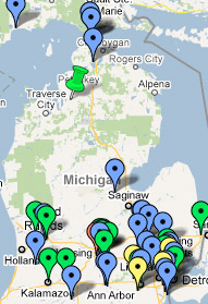
 The Michigan Complete Streets Coalition recently launched a statewide collaborative photo project to document the current conditions of Michigan roads focusing on “complete” and “incomplete” streets.
While the photo project is a statewide effort (currently we have images from Grand Rapids, Flint, Traverse City and Detroit), a pilot website has been launched that specifically highlights Lansing. The goal is to help document the good, bad and ugly of Lansing roadways in order to motivate City Council to adopt a Complete Streets ordinance.
You can visit the new site at:
www.LMB.org/LansingCompleteStreets.html
Recently over 4,500 Lansing registered voters signed a Complete Streets petition, making it the first citizen-driven ballot initiative in the City since 1990. The petition will be presented to City Council on August 10th, 2009 where they will have the opportunity to either adopt the ordinance or put it on the November ballot where citizens can directly vote on it.
The new website is powered using Flickr.com, a popular photo sharing site and uses Tags, or keywords, to pull up images in different categories such as “Bike Lanes,” “Bus Shelters,” “Curb Cuts,” etc. While we are still working on refining the categories and adding descriptions and titles to all the images, we are pleased to announce the Beta version of the site.
We are actively seeking people to document more of Lansing roads, as well as other communities across Michigan. If you are interested in helping to take photos, or if you have comments or suggestions, please contact John Lindenmayer at the League of Michigan Bicyclists.

During the past 20 years there has been a dramatic increase in obesity in Michigan. View animated obesity trends from 1985 to 2008 at the Centers for Disease Control and Prevention's website by clicking the image.
During the past 20 years there has been a dramatic increase in obesity in Michigan. View animated obesity trends from 1985 to 2008 at the Centers for Disease Control and Prevention's website by clicking the image.
New Report Finds Michigan Has 9th Highest Percent of Obese Adults and 26th Highest Percent of Obese and Overweight Children in the U.S. studyTrust for America’s Health, a health advocacy organization, recently released nationwide obesity statistics and found Michigan to be ranked the ninth most obese in America. With 28.8 percent of the Michigan population obese, including more than one-third of 55 to 64-year-olds, Michigan is up from last year’s tenth-place ranking.
Incomplete streets restrict physical activity
When streets are designed only for cars, they deny people the opportunity to choose more active ways to get around, such as walking and biking. Even where sidewalks exist, large intersections and speeding traffic may make walking unpleasant or even unsafe - discouraging any non-motorized travel.
Read the rest of this entry »

Steps and a non ADA compliant curb cut in Flint, Michigan make this sidewalk impossible to use by anyone requiring a mobility device. Photo by Barbara McCann
Please join the Michigan Complete Streets Flickr group and upload your photos and videos of both complete and incomplete streets throughout Michigan.
You are encouraged to add comments that explain the good, bad and ugly of Michigan roadways. Please identify the locations of the photos as specifically as possible in your comments and add geotags to your images so the group can view images on a GIS-based map. (for help see: www.flickr.com/help/screencasts/vol1/)
This site will serve as a database of information to be used in local, statewide and national policy efforts to complete our streets to make them safe for all users.
So next time you are out and about, make sure to grab your camera to help build up our Complete Streets database.
Also make sure to check out other great examples of complete and incomplete streets throughout the country at the National Complete Streets Flickr site: www.flickr.com/photos/completestreets/
A COMPREHENSIVE STRATEGY FOR FULLY FUNDING MICHIGAN’S TRANSPORTATION SYSTEM IN THE 21ST CENTURY
The state of Michigan’s crumbling infrastructure is so bad, even Hollywood has taken notice. Tonight at 9 p.m., The History Channel will air The Crumbling of America, which explores the state of the nation’s highways, bridges, water and sewage systems, and more.
The Crumbling of America explores the nation’s infrastructure problems using expert interviews, on location shooting and computer generated animation to illustrate the kinds of infrastructure disasters that could be just around the bend. Read the rest of this entry »