You are currently browsing the tag archive for the ‘Cycling’ tag.
This post begins an ongoing blog series highlighting various complete street elements, their benefits, and use in Michigan communities. Check back often to catch future posts, and keep a lookout for these elements in your community!
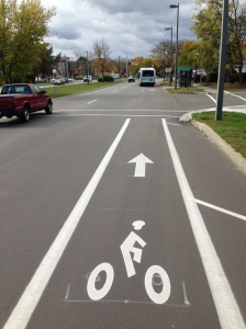
What are Sharrows? Shared-lane markings, often called sharrows, indicate proper lateral positioning for bicyclists riding on roadways. The sharrow design consists of a bicycle symbol with a double set of chevrons, pointing in the direction a bicyclist should ride.
![photo[1]](../../michigancompletestreets.files_subdomain/2013/10/photo1.jpg)
A sharrow on Michigan Ave in Lansing helps a bicyclist ride in good position
- Assisting bicyclists with lateral positioning in a shared lane with on-street parallel parking in order to reduce the chance f a bicyclist’s impacting the open door of a parked vehicle,
- Assisting bicyclists with lateral positioning in lanes that are too narrow for a motor vehicle and a bicycle to travel side by side within the same traffic lane,
- Alerting road users of the lateral location bicyclists are likely to occupy within the traveled way,
- Encouraging safe passing of bicyclists by motorists, and
- Reducing the incidence of wrong-way bicycling.
When to Use Sharrows: Sharrows can be found on roads under 35 mph. Proper placement of sharrows (per MMUTCD) is immediately after intersections, and no more than 250 feet apart thereafter. Some factors that influence lateral placement of sharrows on roads are road width, changes in road width, and the presence or absence of on-street parking. Sharrows can also be used to tell cyclists where to ride when bike lanes stop and start again.
Sharrows placed where bike lanes end can help bicyclists with proper positioning when coming back into the flow of traffic
Safety Benefits: Data suggest that sharrows are effective traffic safety measures for cyclists. A 2010 Federal Highway Administration review found that a high percentage of cyclists rode over sharrows, increasing their visibility and protecting them from collisions with parked-car doors. Cars also afforded cyclists more riding room between them and curbs or parked cars. A 2011 Los Angeles DOT study found that sharrows significantly increase vehicle passing distance, and for cars that do not pass, drivers typically exhibited less aggressive behavior and tailgated less. A 2004 San Francisco study found that cars gave cyclists 3-4 more inches of riding room when sharrows were present. Sharrows were also associated with a 25-35% decrease in sidewalk riders, possibly indicating a greater comfort level with riding on a sharrow-marked road.
Sharrows are often accompanied by signage alerting drivers to be aware of bicyclists
What Drivers Should Know: While it may be tempting to think that the main purpose of sharrows is to denote a shared-space between bicyclists and motorists, sharrows are more about where cyclists should ride on the road—bicycles and vehicles must always share the road in Michigan, regardless of markings. Sharrows do tell motorists where bicyclists are likely to ride, and where bicyclists may be reentering the roadway where bike lanes end.
Cost Considerations: Using sharrows is a cost effective way for municipalities to increase roadway safety. The treatment does not require road widening or repaving, and applying the marking is relatively inexpensive. Material costs for shared-lane markings are around $150 per pavement marking, and around $200-250 depending on the application method. Per the MMUTCD, sharrows are used about every 250 feet and after each intersection. On a two way street, this means around 40 markings per mile at a cost of $6,000. Based on block length and intersection location, though, it is unlikely that a community would need this many sharrows, so costs would likely be lower.
Sharrows are low-hanging fruit that can make a significant and immediate impact. Michigan communities have taken notice, and sharrows are becoming more common as complete streets policies have gained steam. Flint holds the distinction being the first Michigan community to have sharrows, and Michigan State University, Grand Rapids, Royal Oak, Elk Rapids and many others have followed suit.
Have Sharrow in your community? Let us know.
Check out these resources for more information.
What Every Driver Should Know About Bike Lanes
Next Topic: Pedestrian Hybrid Beacons Explained
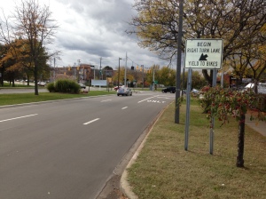
Navigating a multi-lane state highway just got a lot easier for bicyclists on Lansing’s westside and users of the popular Lansing River Trail. A recent resurfacing project on Martin Luther King Blvd/M-99 in Lansing presented an opportunity for the Michigan Department of Transportation (MDOT) to coordinate with the City of Lansing to install MDOT’s first contra-flow bicycle lane. While the addition of only 150′ of pavement marking and a few signs may not seem like a big deal, the recent restriping makes it easy,
M-99 contra-flow bike lane
safe and legal for eastbound bicyclist to cross M-99 at Moore’s River Drive. Prior to this, cyclists would either cross the road illegally, transition to sidewalk, or travel nearly 10 times the distance while navigating 6 lanes of traffic to make a “Michigan left” to avoid the one-way street, when in reality the bicyclists simply wants to travel straight 150′.
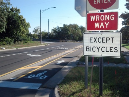
Prior to the project, this segment of Moore’s River Drive, located between northbound and southbound M-99 was an unorganized roadway and despite the do not enter signs, many motorists and bicyclists traveled the wrong way on this one-way street. With the new pavement markings and signs, order is created in the roadway and motorists and eastbound bicyclists have dedicated lanes. Bicyclists traveling westbound on Moore’s River Drive will share the lane as they had done prior to the project.
Now for west Lansing residents who travels this route by bicycle for their commute to work, to the neighborhood parks, the Lansing River Trail and downtown Lansing and East Lansing, this small improvement provides significant connectivity and mobility improvement What a difference a little paint and a few signs make.
By Josh DeBruyn, MDOT Bicycle and Pedestrian Coordinator.