You are currently browsing the monthly archive for October 2013.
This post begins an ongoing blog series highlighting various complete street elements, their benefits, and use in Michigan communities. Check back often to catch future posts, and keep a lookout for these elements in your community!
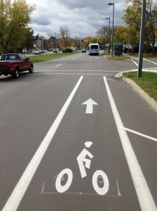
What are Sharrows? Shared-lane markings, often called sharrows, indicate proper lateral positioning for bicyclists riding on roadways. The sharrow design consists of a bicycle symbol with a double set of chevrons, pointing in the direction a bicyclist should ride.
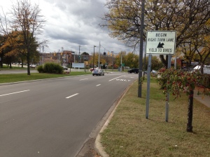
![photo[1]](../../michigancompletestreets.files_subdomain/2013/10/photo1.jpg)
A sharrow on Michigan Ave in Lansing helps a bicyclist ride in good position
- Assisting bicyclists with lateral positioning in a shared lane with on-street parallel parking in order to reduce the chance f a bicyclist’s impacting the open door of a parked vehicle,
- Assisting bicyclists with lateral positioning in lanes that are too narrow for a motor vehicle and a bicycle to travel side by side within the same traffic lane,
- Alerting road users of the lateral location bicyclists are likely to occupy within the traveled way,
- Encouraging safe passing of bicyclists by motorists, and
- Reducing the incidence of wrong-way bicycling.
When to Use Sharrows: Sharrows can be found on roads under 35 mph. Proper placement of sharrows (per MMUTCD) is immediately after intersections, and no more than 250 feet apart thereafter. Some factors that influence lateral placement of sharrows on roads are road width, changes in road width, and the presence or absence of on-street parking. Sharrows can also be used to tell cyclists where to ride when bike lanes stop and start again.
Sharrows placed where bike lanes end can help bicyclists with proper positioning when coming back into the flow of traffic
Safety Benefits: Data suggest that sharrows are effective traffic safety measures for cyclists. A 2010 Federal Highway Administration review found that a high percentage of cyclists rode over sharrows, increasing their visibility and protecting them from collisions with parked-car doors. Cars also afforded cyclists more riding room between them and curbs or parked cars. A 2011 Los Angeles DOT study found that sharrows significantly increase vehicle passing distance, and for cars that do not pass, drivers typically exhibited less aggressive behavior and tailgated less. A 2004 San Francisco study found that cars gave cyclists 3-4 more inches of riding room when sharrows were present. Sharrows were also associated with a 25-35% decrease in sidewalk riders, possibly indicating a greater comfort level with riding on a sharrow-marked road.
Sharrows are often accompanied by signage alerting drivers to be aware of bicyclists
What Drivers Should Know: While it may be tempting to think that the main purpose of sharrows is to denote a shared-space between bicyclists and motorists, sharrows are more about where cyclists should ride on the road—bicycles and vehicles must always share the road in Michigan, regardless of markings. Sharrows do tell motorists where bicyclists are likely to ride, and where bicyclists may be reentering the roadway where bike lanes end.
Cost Considerations: Using sharrows is a cost effective way for municipalities to increase roadway safety. The treatment does not require road widening or repaving, and applying the marking is relatively inexpensive. Material costs for shared-lane markings are around $150 per pavement marking, and around $200-250 depending on the application method. Per the MMUTCD, sharrows are used about every 250 feet and after each intersection. On a two way street, this means around 40 markings per mile at a cost of $6,000. Based on block length and intersection location, though, it is unlikely that a community would need this many sharrows, so costs would likely be lower.
Sharrows are low-hanging fruit that can make a significant and immediate impact. Michigan communities have taken notice, and sharrows are becoming more common as complete streets policies have gained steam. Flint holds the distinction being the first Michigan community to have sharrows, and Michigan State University, Grand Rapids, Royal Oak, Elk Rapids and many others have followed suit.
Have Sharrow in your community? Let us know.
Check out these resources for more information.
What Every Driver Should Know About Bike Lanes
Next Topic: Pedestrian Hybrid Beacons Explained
By Brad Neumann, Michigan State University Extension.
Three years after Michigan’s complete streets legislation became law, design guidance is improving and research into the benefits of complete streets is continuing to emerge, yet funding for projects is lean and implementation seems limited.
The concept of complete streets has officially been on the radar of local governments and transportation agencies in Michigan since 2010, when communities were given new planning and coordination responsibilities related to multimodal transportation planning. Yet some practitioners say there has been little progress made beyond the scattered adoption of resolutions and ordinances. Has the movement towards roadways planned, designed, and constructed to provide appropriate access to all legal users…whether by car, truck, transit, assistive device, foot or bicycle, stalled?
Some proponents of complete streets point to transportation engineers as an obstacle, saying the rule book that engineers have to follow is not accommodating to non-motorized users. However, in September 2013 the Federal Highway Administration (FHWA) publically supported two sets of guidelines that are oriented towards the creation of more walkable and bikeable urban environments. The FHWA encouraged transportation agencies nationwide to turn to the National Association of City Transportation Officials (NACTO) Urban Bikeway Design Guide and the Institute of Transportation Engineers (ITE) Designing Urban Walkable Thoroughfares. The two new guidelines go beyond the American Association of State Highway and Transportation Officials (AASHTO) ‘green book’, which is the principal national transportation design resource. So, it seems the engineering guidance is out there and planners can no longer blame the engineers’ rule books.
Other critics say there has been too much emphasis on promoting the environmental, health, recreation and lifestyle benefits of increased walking and cycling. They say the message needs to refocus on the safety and economic benefits of complete streets. Indeed, there is substantial research connecting health to community design and evidence shows a majority of people currently fall into the recreational cycling category of “Interested but Concerned” (that is, interested in cycling, but concerned about safety). Regarding safety, for decades research has shown that a cyclist riding on the sidewalk is at least twice as likely to get in an accident than a cyclist riding in the street (Wachtel and Lewiston, 1994), and streets with bike lanes have significantly lower crash rates than either major or minor streets without any bicycle facilities. However, even cities with relatively good cycling infrastructure still have cyclists on the sidewalk. When it comes to economic benefits, while there is evidence of increased retail sales resulting from the installation of cycling facilities, at least one researcher points to the need for more rigorous and detailed evidence on the economic impacts of cycling. So, perhaps the research and message is still evolving and that is affecting the implementation of complete streets projects.
Certainly funding for such programs has an impact on implementation. For several years in Michigan municipal finances have been lean, and state and federal transportation funding for non-motorized projects has been reduced, most notably with the MAP-21 (the Moving Ahead for Progress in the 21st Century Act, signed July 6, 2012) amendments to the Federal-Aid Highway Program, which reduced total funding for the Transportation Alternatives Program, the Recreational Trails Program, and the Safe Routes to School Program by 26 percent from fiscal year 2009 funding levels.
Despite the pitfalls and challenges, the Michigan Complete Streets Coalition highlights several communities that have recently passed complete streets resolutions and/or ordinances and the Michigan Department of Transportation continues to expand its support for complete streets projects. Other Michigan communities are finding low cost ways to implement complete streets – strategies that require little more than re-striping and new signage (see MSU Extension news article Road diets can improve pedestrian safety without compromising capacity). Additionally, bicycle and pedestrian advisory committees are conducting cycling safety education and launching public service announcements for greater awareness among motorists and cyclists alike. These low cost measures can go a long way to improving the environment for non-motorized users.
So, yes, pedestrian-oriented engineering guidance is out there, and yes, more research is needed, and yes, funding is a challenge, and yes, progress is being made. To learn more about the status of complete streets in Michigan, visit the Michigan Complete Streets Coalition website. Training is also available on complete streets in Michigan; just contact a Michigan State University Extension land use educator at the Land Use Education Services page.
This article was published by Michigan State University Extension. For more information, visithttp://www.msue.msu.edu. To contact an expert in your area, visit http://expert.msue.msu.edu, or call 888-MSUE4MI (888-678-3464).
Originally posted on October 17, 2013 by Brad Neumann, Michigan State University Extension. Used here with Permission.
Upper Peninsula progress and state-wide web resources were featured at the most recent Complete Streets Advisory Council meeting, which also included MDOT updates on transportation revenue and its Complete Streets Policy implementation. (What are complete streets?)
 Jeff Holt of the Sault Tribe of Chippewa Indians started the meeting off on a positive note with a presentation of complete street successes in the eastern Upper Peninsula. The Sault Tribe has made complete streets a key component of revitalization efforts in communities like Newberry, St. Ignace, Sault St. Marie, and Kinross. Faced with deteriorating and outdated transportation infrastructure, the Sault Tribe has taken a proactive approach to creating a transportation system that facilitates both motorized and non-motorized users. Holt credited this progress to champions within the planning and development department and healthy working relationships between Tribe, county, municipal, and township partners. The communities Holt mentioned have embraced complete streets, with Newberry, Sault St. Marie, and Kinross passing complete street resolutions, and St. Ignace passing a complete streets ordinance. Community members now have the
opportunity to realize the many benefits of complete streets, and Holt presented several figures that suggest residents are taking full advantage of the improved system through increased use, walking and biking programs, bike festivals, and community exercise campaigns.
A transportation revenue update by Frank Raha of MDOT was up next on the agenda, which served mostly to remind the Council and those attending that Michigan faces a sizable shortfall in transportation funding, needing an additional $1.2 Billion per year in transportation investment. This shortfall greatly affects complete street efforts across the state. Various proposals to close this gap have been presented, including increasing registration fees, wholesale gasoline taxes, and increases in sales taxes. Raha said that although it looks like no movement on transportation funding will happen this year, it is crucial for constituents to reach out to legislators and push for funding that will enable complete streets.
Trans4M member John Lindenmayer of the League of Michigan Bicyclists (LMB) then presented an overview of complete street web resources at the Michigan Coalition for Complete Streets webpage. Led by LMB, the Michigan Environmental Council, andAARP, the Coalition represents over 100 organizations, individuals, and businesses. It promotes complete streets policy, and provides resources to communities that would like to adopt complete street initiatives. The site’s Policy Finder provides an easy-to-use, interactive listing of communities across the state that have adopted complete street ordinances and resolutions, along with the actual documents. The site’sResources page provides documents, presentations, and fact sheets that would be invaluable to communities starting in fresh with complete streets. Updates to the site are going on now, and look for a new blog series on complete street elements—coming soon!
MDOT wrapped up the meeting with a brief update from its Complete Streets Internal Team, tasked with creating an implementation plan for the Complete Streets Policyadopted in July of last year. The implementation plan must be available by December 31st of this year, and the Team is on track to meet that goal. Training of MDOT staff on complete streets is in the works, and a public MDOT Complete Streets website is slated to debut at the end of the 1st quarter next year.
The next Complete Streets Advisory Council Meeting will be December 5th, 2013, from 2:00-5:00 p.m. at the Capital Commons buildings. For more information, go tohttp://www.michigan.gov/completestreets
Navigating a multi-lane state highway just got a lot easier for bicyclists on Lansing’s westside and users of the popular Lansing River Trail. A recent resurfacing project on Martin Luther King Blvd/M-99 in Lansing presented an opportunity for the Michigan Department of Transportation (MDOT) to coordinate with the City of Lansing to install MDOT’s first contra-flow bicycle lane. While the addition of only 150′ of pavement marking and a few signs may not seem like a big deal, the recent restriping makes it easy,
M-99 contra-flow bike lane
safe and legal for eastbound bicyclist to cross M-99 at Moore’s River Drive. Prior to this, cyclists would either cross the road illegally, transition to sidewalk, or travel nearly 10 times the distance while navigating 6 lanes of traffic to make a “Michigan left” to avoid the one-way street, when in reality the bicyclists simply wants to travel straight 150′.
Prior to the project, this segment of Moore’s River Drive, located between northbound and southbound M-99 was an unorganized roadway and despite the do not enter signs, many motorists and bicyclists traveled the wrong way on this one-way street. With the new pavement markings and signs, order is created in the roadway and motorists and eastbound bicyclists have dedicated lanes. Bicyclists traveling westbound on Moore’s River Drive will share the lane as they had done prior to the project.
Now for west Lansing residents who travels this route by bicycle for their commute to work, to the neighborhood parks, the Lansing River Trail and downtown Lansing and East Lansing, this small improvement provides significant connectivity and mobility improvement What a difference a little paint and a few signs make.
By Josh DeBruyn, MDOT Bicycle and Pedestrian Coordinator.
If you have a problematic section of road in your community, here is a great chance to make your solution heard. Check out this design contest from Let’s Save Michigan (LSM). Submissions are due October 18th, no design experience necessary. You could win a brand new, Michigan-made bike!

Let’s Save Michigan is giving away a brand new, Michigan-made bicycle for the best design idea for a slice of Michigan roadway. LSM’s Highways for Habitats design competition asks participants to: 1. Identify a road that is a drain on its community, and; 2. Reimagine that road so that it works better for the community it bisects.
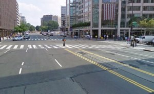
How would you improve a street like this?
The contest seeks, for example, those five-lane roads that divide a quaint downtown into isolated halves, or separate a neighborhood from a public park—those roads that make their surroundings feel unsafe to pedestrians and bicyclists, families with kids and seniors waiting for the bus. Entries should imagine a new version of that street—one that works for all kinds of users, and that encourages community health and economic development.
Contest participants are asked to submit one photo of the site they select, along with their design and a few words about why it makes sense, at this contest submission page (http://www.letssavemichigan.com/highways-for-habitats-entry-submission/) by Friday, October 18. The public will vote online to select the finalists, with the grand prize and a runner-up to be selected by a panel of judges.
A few words on what to enter: LSM is NOT necessarily expecting professional engineer-caliber drawings. Entrants may simply draw a picture, snap a photo of it with a camera phone and submit that. Everyone has a shot at the prize, as long as the entry effectively gets across the brilliant idea.
To help generate ideas, LSM has been collecting examples from all over the world on the Let’s Save Michigan blog for the past few months in a Highways for Habitats blog series. LSM also has compiled resources from around the country about good road design. Take a look and get inspired.
Entries can be uploaded here: http://www.letssavemichigan.com/highways-for-habitats-entry-submission/.
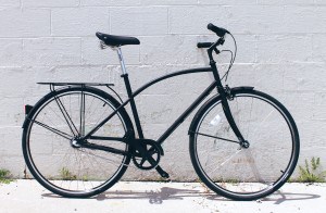
Winner gets a new bike
It’s been done all over the world: Roads can conduct vehicles while helping foster community and economic development. With the help of contest participants, Let’s Save Michigan plans to show Michigan’s leaders how it can be done.
LSM would like to thank the grand prize sponsor, Detroit Bikes! and the runner-up prize sponsor, Cross Country Cycle!
The Michigan Municipal League’s Let’s Save Michigan initiative is a citizen engagement and advocacy effort that promotes smart policies to build a restored Michigan—a state with good jobs, vibrant cities, accessible transportation, and first-rate cultural centers.
Let’s Save Michigan advocates for policies and practices that support, revitalize, and promote Michigan’s cities. For decades, disinvestment and our auto culture have contributed to the decline of our great public spaces. But thankfully, there is a new understanding in many communities and among many of our leaders that we need to reinvest in our public spaces, and rebuild the public amenities that make people choose to live, work, and play in Michigan’s cities of all sizes. For this contest, the nonprofit Let’s Save Michigan asked stakeholders across Michigan to find an underutilized space in their community—an alley, a pocket park, a vacant lot—and then work together with members of the community to create and design a plan to turn that underutilized space into a welcoming, vibrant public place.
###