You are currently browsing the category archive for the ‘Resources’ category.
This post continues an ongoing blog series highlighting various complete street elements, their benefits, and use in Michigan communities. Check back often to catch future posts, and keep a lookout for mid-block pedestrian crossings in your community!
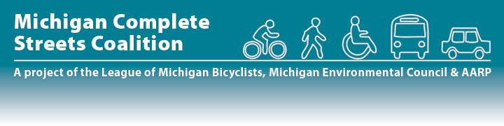
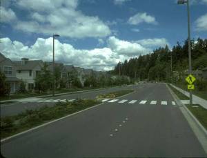
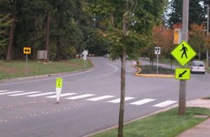
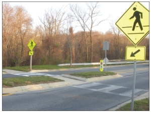
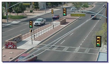
What are Mid-Block Pedestrian Crossings? Mid-block pedestrian crossings are marked crosswalks placed between intersections. They look similar to intersection crosswalks, but often incorporate several design features to increase safety. Mid-block crossings frequently include pedestrian islands, which provide a safe refuge for pedestrians crossing two-way traffic. Users can check traffic one way, cross to the island, and check traffic in the other direction before continuing to cross. Yield lines can be set back to require vehicles to stop farther away from the intersection. Bulb-outs that narrow the roadway can be used to calm traffic by slowing speeds, and can make pedestrians more visible to drivers. Where traffic volumes are heavy, mid-block crossings can be signalized to further increase safety and comfort.
Why Use Mid-Block Pedestrian Crossings? Many people do not go out of their way to cross at established intersections. Instead, they choose to cross the street using the most direct route, even if that means crossing several lanes of busy traffic. Mid-block pedestrian crossings decrease random and unpredictable crossings associated with a high risk of collisions, especially in areas that are heavily travelled by pedestrians or where block lengths are long.
When to Use Mid-Block Pedestrian Crossings: An engineering study should be completed to determine the need for a mid-block crossing, which incorporates roadway width, traffic volume, traffic speed and type, desired lines for pedestrian movement and adjacent land use. Heavily traveled areas that have high incidences of random crossings are good candidates for mid-block crossings, including schools, shopping centers, transit centers, and college campuses.
The above factors also determine whether bulb-outs, pedestrian islands, and signals should be incorporated into the mid-block crossing design. In general, local roads with low speeds and low traffic volumes are less likely to need these additional elements. As speed limits, number of lanes, and traffic volumes increase, these additional traffic calming and safety elements become increasingly necessary.
Safety Benefits: Mid-block locations account for more than 70% of pedestrian fatalities. Mid-block pedestrian crossings increase safety by decreasing random and unexpected pedestrian crossings. As stated before, people tend to cross where it is most convenient for them to cross, creating a high risk of collisions. Mid-block pedestrian crossings consolidate pedestrian traffic and allow drivers to predict and expect pedestrian traffic. Around 83% of pedestrians surveyed in an East Lansing, MI study changed their crossing behaviors where mid-block crossings were present. Where pedestrian islands have been included in the crosswalk design, pedestrian crashes were reduced by 46% and vehicle crashes were reduced by 39%. Because mid-block crosswalks can be difficult to use for individuals with visual impairments, adding a crosswalk signal to the crossing will help make the treatment safer for all users.
What Drivers Should Know: While mid-block pedestrian crossings help drivers know where pedestrians are most likely to cross, some pedestrians may still choose to cross at random points along the road. Accordingly, drivers should remain alert for pedestrians crossing outside of the crosswalk. Be aware of signage that will signal a mid-block crossing is approaching. When coming up to unsignalized and signalized mid-block crossings, drivers should prepare to yield in anticipation of pedestrians crossing. Where a pedestrian is on a crosswalk or when alerted by signal, a driver must stop behind the yield lines that proceed the crosswalk.
Cost Considerations: Costs for mid-block pedestrian crossings can vary significantly with mid-block characteristics and the need for pedestrian islands, signals, or bulb-outs. Additional treatment costs include Bulb-outs, which can cost between $5,000 and $25,000 per corner, pedestrian islands, which can run between $4,000 and $30,000, and countdown/crosswalk signals, which can cost between $5,000 and $15,000. More Expensive Pedestrian Hybrid Beacons can be included if deemed necessary. Adding these elements during planned construction will help to decrease project costs.
Mid-block pedestrian crossings are common in Michigan. A few examples include: East Lansing, which has a mid-block crosswalk that covers five lanes of traffic, and includes a pedestrian shelter; a short mid-block crossing between Michigan and Allegan along Washington Street’s business district in Lansing; and a crossing outside Frost Elementary School in Jackson.
Have mid-block pedestrian crossings in your community? Let us know.
Check out these resources for more information:
Best Design Practices for Walking and Bicycling in Michigan (Pages 26, 27, 29, and 32)
Crossing Enhancements Commonly Used in Mid-block Crossings
FHWA Course of Mid-block Crossings
MDOT Presentation on Design Ideas to Improve Pedestrian and Bicycle Safety
Mid-block Fact Sheet from Kansas DOT
Next Topic: Road Diets
Previous Topic: Contra-flow Bike Lanes
This post begins an ongoing blog series highlighting various complete street elements, their benefits, and use in Michigan communities. Check back often to catch future posts, and keep a lookout for these elements in your community!
What are Sharrows? Shared-lane markings, often called sharrows, indicate proper lateral positioning for bicyclists riding on roadways. The sharrow design consists of a bicycle symbol with a double set of chevrons, pointing in the direction a bicyclist should ride.
![photo[1]](../../michigancompletestreets.files_subdomain/2013/10/photo1.jpg)
A sharrow on Michigan Ave in Lansing helps a bicyclist ride in good position
- Assisting bicyclists with lateral positioning in a shared lane with on-street parallel parking in order to reduce the chance f a bicyclist’s impacting the open door of a parked vehicle,
- Assisting bicyclists with lateral positioning in lanes that are too narrow for a motor vehicle and a bicycle to travel side by side within the same traffic lane,
- Alerting road users of the lateral location bicyclists are likely to occupy within the traveled way,
- Encouraging safe passing of bicyclists by motorists, and
- Reducing the incidence of wrong-way bicycling.
When to Use Sharrows: Sharrows can be found on roads under 35 mph. Proper placement of sharrows (per MMUTCD) is immediately after intersections, and no more than 250 feet apart thereafter. Some factors that influence lateral placement of sharrows on roads are road width, changes in road width, and the presence or absence of on-street parking. Sharrows can also be used to tell cyclists where to ride when bike lanes stop and start again.
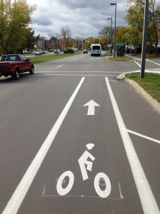
Sharrows placed where bike lanes end can help bicyclists with proper positioning when coming back into the flow of traffic
Safety Benefits: Data suggest that sharrows are effective traffic safety measures for cyclists. A 2010 Federal Highway Administration review found that a high percentage of cyclists rode over sharrows, increasing their visibility and protecting them from collisions with parked-car doors. Cars also afforded cyclists more riding room between them and curbs or parked cars. A 2011 Los Angeles DOT study found that sharrows significantly increase vehicle passing distance, and for cars that do not pass, drivers typically exhibited less aggressive behavior and tailgated less. A 2004 San Francisco study found that cars gave cyclists 3-4 more inches of riding room when sharrows were present. Sharrows were also associated with a 25-35% decrease in sidewalk riders, possibly indicating a greater comfort level with riding on a sharrow-marked road.
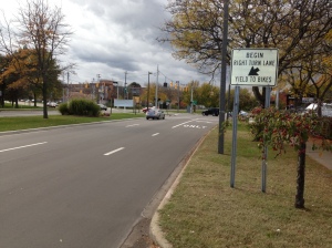
Sharrows are often accompanied by signage alerting drivers to be aware of bicyclists
What Drivers Should Know: While it may be tempting to think that the main purpose of sharrows is to denote a shared-space between bicyclists and motorists, sharrows are more about where cyclists should ride on the road—bicycles and vehicles must always share the road in Michigan, regardless of markings. Sharrows do tell motorists where bicyclists are likely to ride, and where bicyclists may be reentering the roadway where bike lanes end.
Cost Considerations: Using sharrows is a cost effective way for municipalities to increase roadway safety. The treatment does not require road widening or repaving, and applying the marking is relatively inexpensive. Material costs for shared-lane markings are around $150 per pavement marking, and around $200-250 depending on the application method. Per the MMUTCD, sharrows are used about every 250 feet and after each intersection. On a two way street, this means around 40 markings per mile at a cost of $6,000. Based on block length and intersection location, though, it is unlikely that a community would need this many sharrows, so costs would likely be lower.
Sharrows are low-hanging fruit that can make a significant and immediate impact. Michigan communities have taken notice, and sharrows are becoming more common as complete streets policies have gained steam. Flint holds the distinction being the first Michigan community to have sharrows, and Michigan State University, Grand Rapids, Royal Oak, Elk Rapids and many others have followed suit.
Have Sharrow in your community? Let us know.
Check out these resources for more information.
What Every Driver Should Know About Bike Lanes
Next Topic: Pedestrian Hybrid Beacons Explained
 Earlier this month, Federal Highway Administration (FHWA) announced support for two guidelines, which can help communities, especially more urban ones, plan and design safe and convenient facilities for those who walk and/or bike.
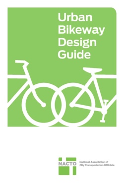
In the recent memorandum, the FHWA encourages its division throughout the nation to consider relying upon The National Association of City Transportation Officials (NACTO) Urban Bikeway Design Guide and the Institute of Transportation Engineers (ITE) Designing Urban Walkable Thoroughfares.
These guides build upon The American Association of State Highway and Transportation Officials (AASHTO) “green book”, which is the primary national resources for planning, designing, and operating bicycle and pedestrian facilities.
“The FHWA’s support for the NACTO guidelines gives communities and our state DOT an additional toolkit to help them provide safe and effective infrastructure that better serves bicyclists.” said John Lindenmayer, Advocacy & Policy Director for the League of Michigan Bicyclists. “Providing safe bicycle infrastructure that connects people to places goes along way to improve a bicyclists’ comfort level and overall feeling of safety on the road. These innovative bikeways certainly can play a big role in increasing ridership, which in and of itself, can help reduce the number of bicycle crashes within a community. It’s a win-win. This is an exciting opportunity for Michigan communities and LMB strongly encourages road agencies across the state to incorporate these design standards where appropriate.”
NACTO, which is an association of 15 major US cities (including Detroit) formed to exchange transportation ideas, insights, and practices and cooperatively approach national transportation issues, has published two editions of its bikeway design guide with with another edition set to be released on September 23, 2013. Unlike AASHTO’s more traditional guide, NACTO’s include protected bicycle lanes and other innovative best practices.
The FHWA memorandum also highlighted Michigan as a case study to illustrate use of treatments illustrated in the NACTO Guide by State or local DOTs:
Example 1: Michigan DOT’s Buffered Bike Lanes
One of the innovative bicycle facilities discussed in the NACTO Urban Bikeway Design Guide is buffered bike lanes. Buffered bike lanes create more space between motor vehicles and bicycles by delineating extra space between the bike lane and parked cars and/or a motor vehicle lane. Buffered bike lanes can be implemented if the pavement markings and channelizing devices are compliant with the MUTCD (see Bicycle Facilities and the Manual on Uniform Traffic Control Devices). Michigan DOT developed a video that describes their efforts to install buffered bike lanes in Oakland County (see Northwestern Highway Bicycle Lane: A Safer Place to Ride). Michigan DOT also developed a brochure that explains buffered bike lanes to the public (see What Every Michigan Driver Should Know About Bike Lanes).
![]() The Road Commission for Oakland County (RCOC) Board of Road Commissioners, at its regular meeting today (Thursday, Sept. 27), accepted a set of Complete Streets guidelines intended to steer the agency in its efforts to apply complete streets concepts to county roads.
The Road Commission for Oakland County (RCOC) Board of Road Commissioners, at its regular meeting today (Thursday, Sept. 27), accepted a set of Complete Streets guidelines intended to steer the agency in its efforts to apply complete streets concepts to county roads.
The guidelines were compiled by the RCOC Complete Streets Review Committee, which, in addition to RCOC staff, included a number of county and local officials, transportation experts and others. The committee created the guidelines over the last 15 months.
“We strongly support the concept of complete streets and the idea that public roads should be as safe and accessible as possible for all legal users,” stated ROCC Chairman Eric Wilson. “These guidelines represent our commitment to that philosophy.”
The guidelines were adopted unanimously by the three-member RCOC Board. Board Member Ron Fowkes served on the Complete Streets Review Committee.
“This was a very constructive process,” Fowkes said of the committee’s work. “The committee included a broad spectrum of opinions related to complete streets, and that diversity of opinion is reflected in the guidelines. This document will guide this agency’s approach to all road users as we move forward.”
The guidelines also acknowledge that the agency must operate with the resources available. “We are wholly committed to complete streets and to all road users,” stated RCOC Managing Director Dennis Kolar. “But, we also acknowledge that resources are scarce, and that we have to balance the needs of various user groups.”
He added that the process of creating the Complete Streets Guidelines has reinforced for RCOC the critical importance of the agency’s partners in these efforts. “This process reminded us that we must work closely with all of our partners,” Kolar said, “especially the communities, and that this collaboration must come as early as possible in the road-project selection and design processes.”
The guidelines review the numerous groups of legal road users and their needs and discuss how they might be accommodated while acknowledging that Michigan is in the midst of a road-funding crisis that makes it hard for road agencies to merely maintain the existing road system. The guidelines sum up this challenge as follows: “Complete streets implementation, as a component of an improved, well-functioning transportation system, has entered the depleted scene of transportation financing, where it must compete for limited funding. State and local leaders are challenged to think in new ways about how to plan and fund the infrastructure that will provide for the future economic growth of the area.”
Download the RCOC Complete Streets Guidelines (PDF)
After the State Transportation Commission officially adopted a Complete Streets policy on July 26th, 2012, as required by PA 134 and PA 135 of 2010, the Michigan Department of Transportation wasted no time in getting the word out about the good news. Upon request from the Michigan Complete Streets Advisory Council, MDOT recently published this one-page leave behind regarding the new policy in an effort to help inform internal staff, as well as road commissions, municipalities, and other interest groups across the state.
The one-pager includes the following vision for Complete Streets in Michigan:
- A transportation network that is accessible, interconnected and multimodal and that safely and efficiently moves goods and people of all ages and abilities throughout the State of Michigan.
- A process that empowers partnerships to routinely plan, fund, design, construct, maintain and operate complete streets that respect context and community values.
- Outcomes that will improve economic prosperity, equity, accessibility, safety and environmental quality.
Download the one-pager or preview it below.
Reposted from LMB.org
CycleSafe to offer bike parking discounts to communities with Complete Streets and/or bike parking policies.
League of Michigan Bicyclists member [and Michigan Complete Streets Coalition partner], CycleSafe, Inc. is pleased to announce that they are now offering municipal discounts on their Michigan-made bicycle parking products to communities with either a Complete Streets resolution, Complete Streets ordinance, and/or a bike parking ordinance. The promotion is tiered, offering communities with ordinances larger discounts over communities with resolutions. Communities that have adopted both a Complete Streets ordinance and a bike parking ordinance are eligible for the greatest discounts.
CycleSafe manufactures a wide range of bicycle parking products from bicycle lockers and bicycle shelters to decorative bike racks, utilizing Michigan vendors with products still in use for over 30 years.
A letter from the Michigan Complete Streets Coalition will soon be mailed to all city council members, township supervisors, mayors and transportation officials in the over 50 Michigan communities who have adopted a Complete Streets ordinance or resolution congratulating them on their accomplishments and recommending a number of potential next steps on how to make their communities more pedestrian and bicycle friendly. The letter also references a number of available incentives for communities with Complete Streets policies, including this new bicycle parking discount.
Communities applying for the discount will need to provide a copy of their Complete Streets and/or bike parking policies and reference discount code MI-2012CS. For CycleSafe product information and to learn more about this new incentive, please contact CycleSafe by phone at (888) 950-6531 or by email at [email protected] or visit their website at www.cyclesafe.com.
Reposted from LMB.org
FederalFederal Transit Administration (FTA) has issued a policy statement in today’s Federal Register establishing that pedestrian improvements within a half mile radius of a transit facility and bicycle improvements within a 3-mile radius of the transit facility are considered to have a de facto relationship to the transit facility. This is great news as it simplifies the eligibility determinations for use of transit funds for bicycle and pedestrian improvements.
The majority of FTA’s grant programs allow money to be spent on the design, construction, and maintenance of walking and biking projects that “enhance or are related to public transportation facilities.” But how do they determine if such a relationship exists? Until today’s announcement, the FTA had used 1,500 feet from the transit stop or station as the rule of thumb.
Additionally, in response to public comments, the FTA also included a stipulation that allows projects located beyond these distances to be eligible if walkers and cyclists could reasonable be expected to make longer trips.
LMB is extremely pleased that this new policy recognizes that successful transit depends on safe and convenient access to transit stops, especially within nearby walk and bike catch basins. Making bicycling and walking safe and attractive makes transit more accessible, practical and appealing. In addition, providing secure bike parking is far cheaper than building surface or structure automobile parking.
You can read the entire policy statement here and read more on the history of this significant policy change on the League of American Bicyclists’ blog. Below are a few excerpts specifically related to bicycling and complete streets.
“Distances beyond the ‘‘walkshed” of public transportation stops and stations may, in fact, be within the range of a short bicycle trip. Indeed, as one author stated, ‘‘[bicycles] are the perfect transportation choice for a short one- to three-mile trip to and from a transit station.” Providing secure parking and other amenities for bicycles and cyclists at public transportation stops or stations can be less expensive than providing parking for automobiles. Access to public transportation allows bicyclists the opportunity to make longer trips. Further, where physical conditions prevent a continuous bicycle trip, public transportation can provide a link to previously inaccessible destinations.”
“In addition, investing in a ‘complete street’ concept stimulates private-sector economic activity by increasing the viability of street-level retail small businesses and professional services, creating housing opportunities and extending the usefulness of school and transit facilities.” As one leading scholar noted, ‘‘Pedestrian and bicycle traffic use fewer resources and affect the environment less than any other form of transport.” If we are to create livable communities, ‘‘the range of transportation choices available to all Americans-including transit, walking, bicycling, and improved connectivity for various modes-must be expanded.”
 On July 11, 2011, Birmingham’s City Commission passed a Complete Streets resolution in support of multi-modal transportation planning to improve travel choices in the city. The resolution directs city staff to develop a set of proposed policies and procedures to implement Complete Streets practices. The City Commission voted unanimously to support the resolution and recognizes that while the city has long prioritized walkability, additional work remains to serve all user groups. This resolution comes after several discussions at the Planning Board about the benefits of Complete Streets and approaches to implementation. The city will move forward with identifying the most effective way to implement Complete Streets practices in its road planning process and hopes to work with other communities throughout Michigan to ensure that the city is employing best practices. By passing the Complete Streets resolution, Birmingham renews its commitment to promoting safe and convenient mobility options and improving the quality of life for all its residents.
Download Birmingham’s Complete Streets resolution
Birmingham Patch coverage
Bikes Belong, a national organization sponsored by the U.S. bicycle industry with the goal of putting more people on bicycles more often, is accepting applications for Community Partnership Grants. The grants are designed to foster and support partnerships between local governments, nonprofit organizations, and local businesses working to improve the environment for bicycling.
Grants of up to $10,000 will be largely will be awarded to fund the construction or expansion of bicycle facilities such as bike lanes, trails, and paths. The grants committee also will consider advocacy projects that promote bicycling as a safe and accessible mode of transportation.
To be eligible for a grant, a partnership must include collaboration between at least one city/county government office or department; one nonprofit organization with a mission specific to bicycling, trails, or recreation; and one local business.
The Michigan Department of Transportation (MDOT) recently posted the following Complete Streets FAQ document to their website.


